
In brief
- Historical occupation from the 5th century by the rulers of the Kingdom of Dumnonia and Mediterranean trade exchanges.
- Erection of the medieval fortress in 1233 by Richard, Earl of Cornwall.

- Presence of folded rocks over 300 million years old protected by the Cornwall National Landscape.

- Inauguration in 2019 of an access footbridge designed by architects Ney & Partners and William Matthews Associates.

At the south-western tip of England, Cornwall unfolds a spectacular coastline where sheer cliffs plunge directly into the Atlantic. In this landscape battered by winds and tides, Tintagel Castle remains an emblematic site of British history and legend, suspended between land and ocean. This dramatic rocky peninsula juts proudly out into the tempestuous waters of the Bristol Channel, offering a grandiose panorama where the brute force of nature meets the vestiges of a fascinating past. The region of Cornwall, famous for its wild coastal landscapes, open moors and centuries-old Celtic traditions, shelters here one of its most precious jewels. Every year, the fascination exerted by this unique place attracts history enthusiasts, walkers pacing the famous coastal path and lovers of legendary tales who come to explore the mystery-shrouded ruins crowning the cliff.
The dramatic character of the local geography lends Tintagel a singular atmosphere. The contrast between the dark waters of the ocean, the vibrant green of the coastal vegetation and the austere grey of the stone offers a memorable visual experience. Access to this extraordinary site was long a physical and technical challenge, reinforcing the sense of isolation and natural protection surrounding the headland. Over the seasons, the changing light of the Cornish sky metamorphoses the perspectives on the ruins, imparting to the landscape a poetic and almost surreal dimension that has captured the collective imagination for generations.


A strategic bastion since the 5th century
A strategic bastion born in the 5th century
Long before the construction of the fortress visible today, the headland of Tintagel held a major position within the kingdom of Dumnonia. Archaeological research has unearthed fine tableware and amphorae imported from the Mediterranean basin, testifying to intense commercial trade from as early as the 5th century. It was later, in 1233, that Richard, Earl of Cornwall, ordered the erection of a fortified castle taking advantage of the steep terrain.
During the Early Middle Ages, Tintagel established itself as a seat of power of paramount importance for the local political and commercial elite. The geographical position of the island, formerly connected to the mainland by a natural spit of land that has now vanished, offered exceptional passive defence against maritime and land invasions. The rulers of the kingdom of Dumnonia, which stretched across a large part of south-west Great Britain after the departure of the Roman legions, used this strategic site as a seasonal royal residence and a key trading post.
Excavations conducted on site by historians and archaeologists have revealed the presence of complex drystone structures, bearing witness to a dense and organized occupation. The discovery of luxury ceramics, containers of olive oil and wine originating from the Byzantine Empire and North Africa proves that this rugged rock was not a mere isolated refuge, but a hub of international trade. The wealth accumulated by the lords of Tintagel rested notably on the control of sea routes and the mineral resources of Cornwall, a region renowned since Antiquity for its deposits of tin and copper.
When in 1233, Richard, Earl of Cornwall and brother of King Henry III of England, set out to build the medieval fortress whose vestiges can still be admired today, his choice was motivated as much by military considerations as by the symbolic desire to align himself with the prestigious stories attached to the site. The construction represented a considerable engineering challenge for the period. 13th-century masons had to integrate stone walls into the slippery slopes and sheer cliffs of the headland. The castle consisted of a lower courtyard on the mainland and an upper courtyard situated on the island, linked by the natural passage that crossed the ravine. Over the centuries, the medieval castle gradually lost its military utility, as logistical constraints and the harsh maritime climate rendered its maintenance particularly difficult.


The indelible mark of Arthurian myth
The Arthurian myth and the mark of the 12th century
The global renown of Tintagel took shape in the 12th century under the pen of Geoffrey of Monmouth, who set the mythical birth of King Arthur at this location. Since 2016, the bronze statue Gallos, created by artist Rubin Eynon, stands guard over the site looking out to sea. This majestic work, whose name means “power” in the Cornish language, serves as a reminder of the deep roots of Celtic tales in the local landscape.
In his famous 12th-century work, “Historia Regum Britanniae”, Geoffrey of Monmouth inextricably linked Tintagel to the figure of the legendary ruler. According to this founding narrative which shaped European literature of the Middle Ages, it was within these impregnable walls that King Uther Pendragon, through the enchantments of the wizard Merlin, conceived Arthur with Queen Igraine. This mythological association transformed the Cornish rock into a place of romantic and spiritual memory, inspiring generations of British writers, poets and painters, particularly during the Victorian era when the rediscovery of the Matter of Britain sparked a huge resurgence of interest in the site.
The installation of the sculpture Gallos in 2016 constitutes a striking tribute to this intangible heritage. Standing over two metres tall, this bronze silhouette depicts a royal figure draped in a flowing cloak, holding a sword and looking out towards the infinite horizon of the Atlantic Ocean. The artist Rubin Eynon expertly integrated the work into its natural environment: the metal, gradually patinated by salt air and weathering, seems to emerge directly from the cliff face. The void left at the centre of the statue symbolizes the mystery surrounding the historical or legendary figure of Arthur, while letting through the evening light and the coastal wind.
In addition to the figure of Arthur, oral and literary tradition also links Tintagel to other famous tales from Celtic lore, such as the tragic story of Tristan and Iseult. This network of interconnected stories bestows upon the site an imaginary dimension unique in Great Britain. Visitors who tread the steep paths do not merely discover an architectural heritage in ruins, but immerse themselves in a mythical geography where every sea cave, like the famous Merlin’s Cave located at the foot of the rocky outcrop, carries the echo of centuries-old tales.
A 300-million-year geological history
An exceptional geological heritage
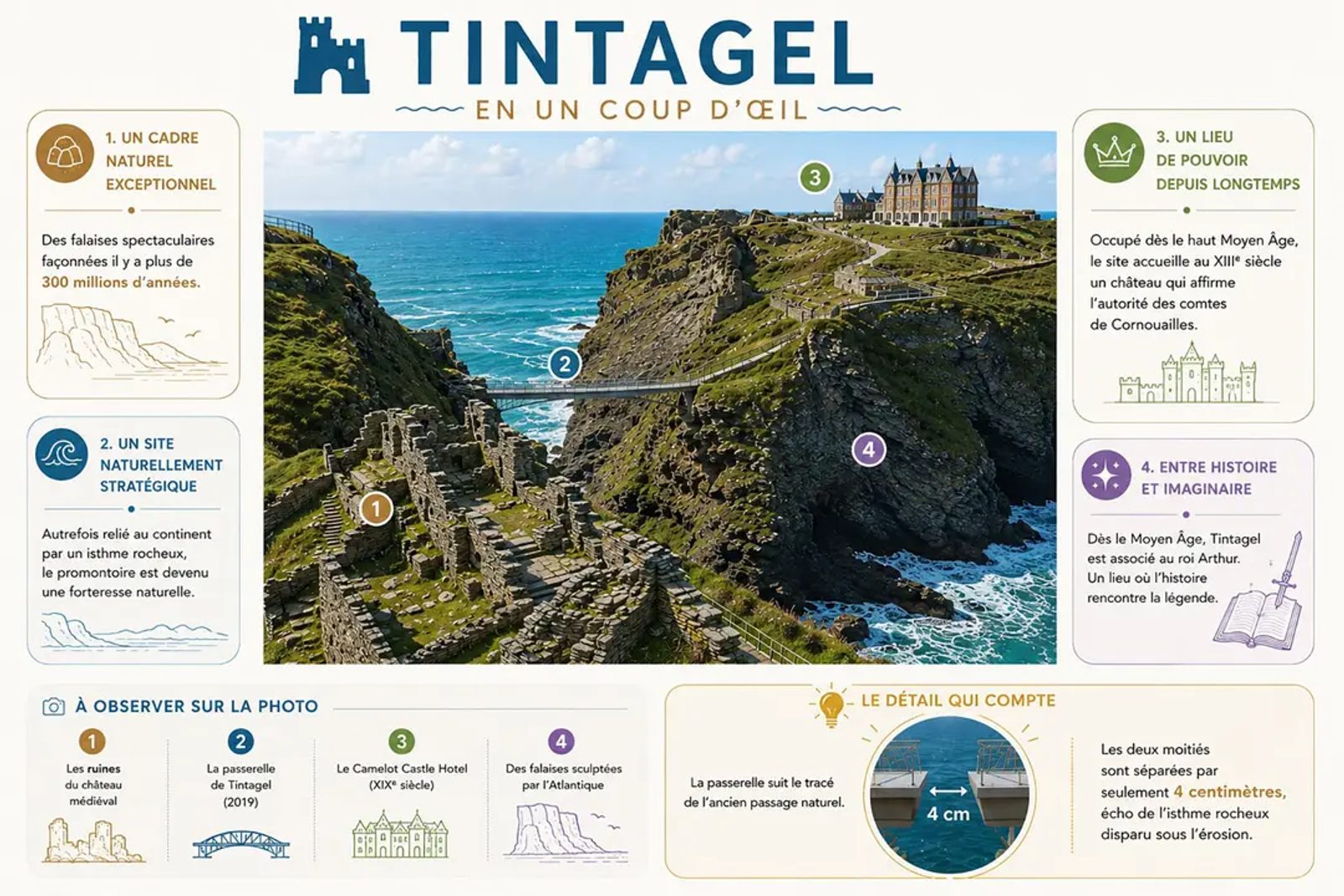
The steep relief of Tintagel lies at the heart of the Cornwall National Landscape, an area protected for the exceptional value of its biodiversity and scenery. The folded rocks forming the base of the cliffs were created more than 300 million years ago during major tectonic movements. The continual assault of Atlantic waves constantly reshapes the coastline, creating faults and sculpting the rock walls over the centuries.
The geological makeup of the Tintagel area is characterized by a complex alternation of slate schists and altered volcanic rocks, formed during the Palaeozoic era. The intense deformations suffered by the Earth’s crust during the Variscan orogeny folded these rock layers, creating impressive geological structures visible along the cliff face. The variety of colours in the stone, ranging between dark grey, olive green and midnight blue, bears witness to the mineralogical richness of the Cornish subsoil.
The relentless action of the Atlantic Ocean is the main agent transforming the landscape. Powerful swells from the open sea strike the base of the cliffs, seeping into the smallest fissures to exert devastating hydraulic pressure. Over the centuries, this coastal erosion process has caused successive rockfalls, carving out impressive sea caves and gradually isolating the headland from the rest of the coast. This natural dynamic offers an insightful laboratory for geologists and serves as a reminder of the intrinsic fragility of monuments built by the sea.
The protective status granted by the Cornwall National Landscape ensures the preservation of this spectacular and fragile environment. The cliffs and verdant slopes host specific flora adapted to sea spray, as well as a highly diverse avian fauna. Seabird species take advantage of inaccessible rock cavities to breed in safety, while surrounding coastal waters regularly welcome marine mammals. Site management focuses on preserving this delicate balance between biodiversity conservation, geological study and welcoming the public.
Contemporary architecture serving heritage
Contemporary architecture in the service of history
Under the prolonged effect of erosion, the natural isthmus once connected to the mainland collapsed, isolating the ruins on their rocky outcrop. Opened in 2019, the new footbridge designed by Ney & Partners and William Matthews Associates re-links the headland. The structure is separated at its centre by a narrow gap measuring just a few centimetres, deliberately materializing the void left by the disappearance of the ancient passage along the South West Coast Path.
The loss of the original strip of land had rendered crossing the ravine particularly arduous for visitors, who previously had to descend to the bottom of the valley via steep steps before climbing up the other side. To resolve this accessibility issue while respecting the visual and archaeological integrity of the site, an international architectural competition was held. The work of art created by the Ney & Partners design studio in collaboration with William Matthews Associates represents a masterpiece of modern engineering and landscape sensitivity.
The bridge spans a distance of several dozen metres over the chasm, at an impressive height above the sea. Its design relies on two independent cantilevers built of Corten steel and local slate, reaching towards each other from both sides of the cliff without ever fully touching. The break at the centre of the footbridge, measuring only a few centimetres across, forms a striking spatial metaphor: it reminds visitors that they are crossing a boundary between present and past, while recalling the void left by the natural collapse of the historic isthmus.
Remarkable integration along the South West Coast Path
The integration of the 2019 footbridge into the South West Coast Path walking route illustrates a remarkable success in land management. This National Trail, which circles the entire south-western peninsula of England, has its route enriched by this spectacular crossing. The materials chosen by the designers harmonize perfectly with the natural colour palette of the site: Corten steel develops a rusty patina recalling the hue of oxidized rock, while Cornish slate paving visually extends the stone slabs used in the medieval ruins.
Thanks to this elegant and bold structure, the overall visitor experience has been completely transformed. Access to the headland is now open to a wider audience, allowing historic structures and seascapes to be admired from fresh perspectives. The subtle blend of preserving multi-millenary historical heritage, respecting a protected geological environment and introducing first-class contemporary architecture makes Tintagel a internationally recognized example of cultural landscape management.
To go further
- Add Futura to your favourite sources
- Follow us on Discover
- Follow us on Google News
- geology field notebook
- where to find the outlook address book file